

Morawa Airstrip WA

Morawa Airstrip in WA is a small, regional airport. The Airstrip is one nautical mile from the town of Morawa.
It is used by the Royal Flying Doctor Service and recreational pilots.
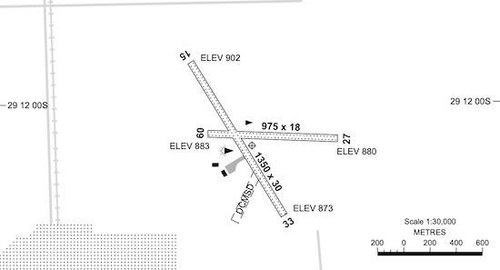
Morawa Airstrip WA Runway Diagram
| Elevation 902 | Area Forecast 60 | Strip Direction 09 / 27 : 15 / 33 |
| GPS Position 29° 1205 S 116° 0119 E | ALA Code YMRW | Strip Length 975 : 1350 |
| WAC Chart 3551 | FIA Melb Centre 124.8 | Strip Surface Sand, Gravel : Sand, Gravel |
| Owner / Operator Shire of Morawa 08 9971 1004 | Windsock 1 – N of Tarmac 1 – Between RWYs on E side | ASIC Security / Vis Vest No |
| Fuel No | Distance to Town 1 NM | Lighting Emergency only |
| Aircraft Parking Yes | Transport – | Landing Fees – |
| Special Procedures and Comments: CTAF 126.7 |
Get Directions Morawa Airstrip, Wa, AUSTRALIA
TodayOpen Now~- Monday09:00 - 17:00
- Tuesday09:00 - 17:00
- Wednesday09:00 - 17:00
- Thursday09:00 - 17:00
- Friday09:00 - 17:00
- Saturday09:00 - 17:00
- Sunday09:00 - 17:00
Contact with business owner
Your request has been submitted successfully.