Broome Airport WA
Broome Airport in WA is the regional hub of the northwestern part of Western Australia. It is considered the gateway to the Kimberley region.
The airport field was attacked on the morning of 3 March 1942, during World War II. The attack on Broome resulted in at least 88 deaths. The airport field was being used by the Royal Australian Air Force (RAAF) and allies, the Japanese raid destroyed at least 22 aircraft, parts of which are still on display to this day at Broome Historical Museum.

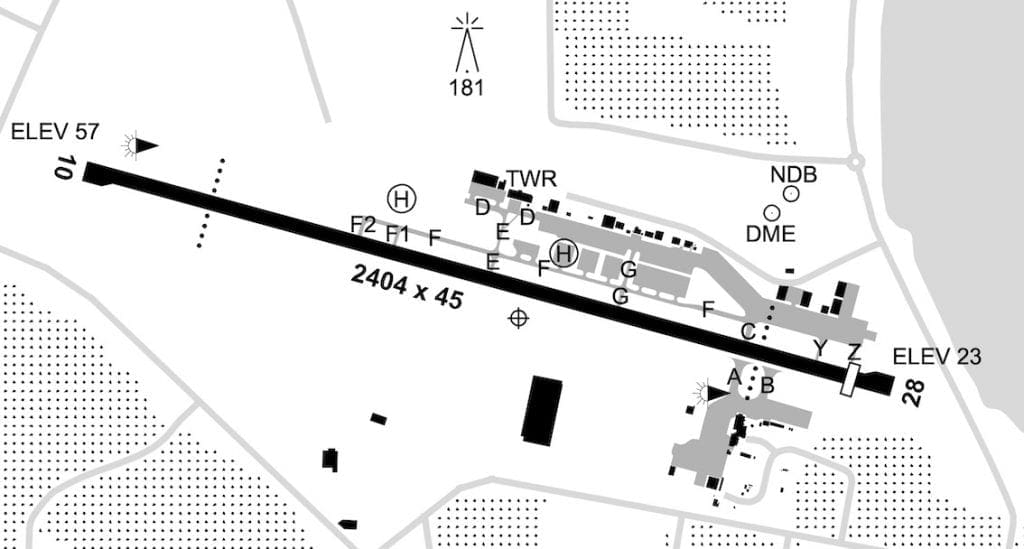
| Elevation 57 | Area Forecast 69 | Strip Direction 10 / 28 |
| GPS Position 17° 5658 S 122° 1340 E | ALA Code YBRM | Strip Length 2404 |
| WAC Chart 3223 | FIA Bris Centre 123.95 ATIS 128.2 SMC 121.7 TWR. 126.0 | Strip Surface Sealed |
| Owner/Operator Broome International Airport (08) 9194 0600 Duty Groundsman 0437 900 566 | Windsock 1 – LH THR of 10 1 – SW side of RWY 28 near TWY A | ASIC Security / Vis Vest Yes |
| Fuel AirBP 0600 – 1800 WST AVGAS JetA1 0436 412 616 Radio 129.9 | Distance to Town 0.9 NM | Lighting PAL + AFRU 126.0 |
| Aircraft Parking GA parking on N side of RWY via TWY C, E, F & G Parking marked on pavement or by yellow cones. | Transport Taxi (08) 9192 3316 | Landing Fees Yes |
Special Procedures and Comments: CTAF 126.0
Bird Hazards.
Some CTAF shielding possible on ground.
Check ERSA for AP Operational Procedures.

